Mount Madison, Adams, Jefferson Hike
This is a report of a hike to Mounts Madison, Adams and Jefferson in the White Mountains in New Hampshire, USA.
Date: 2008-04-20
Total distance: 13.5 miles (21.6 km)
Total Time: 10 hours 48 minutes
Start elevation: 1300 ft (397 m)
Peaks: Mount Madison (5366 ft, 1637 m), Mount Adams (5799 ft, 1769 m), Mount
Jefferson (5716 ft, 1742 m).
The following is a picture from Google Earth that does not reflect the weather
condition of the hike. More pictures are at Picasa.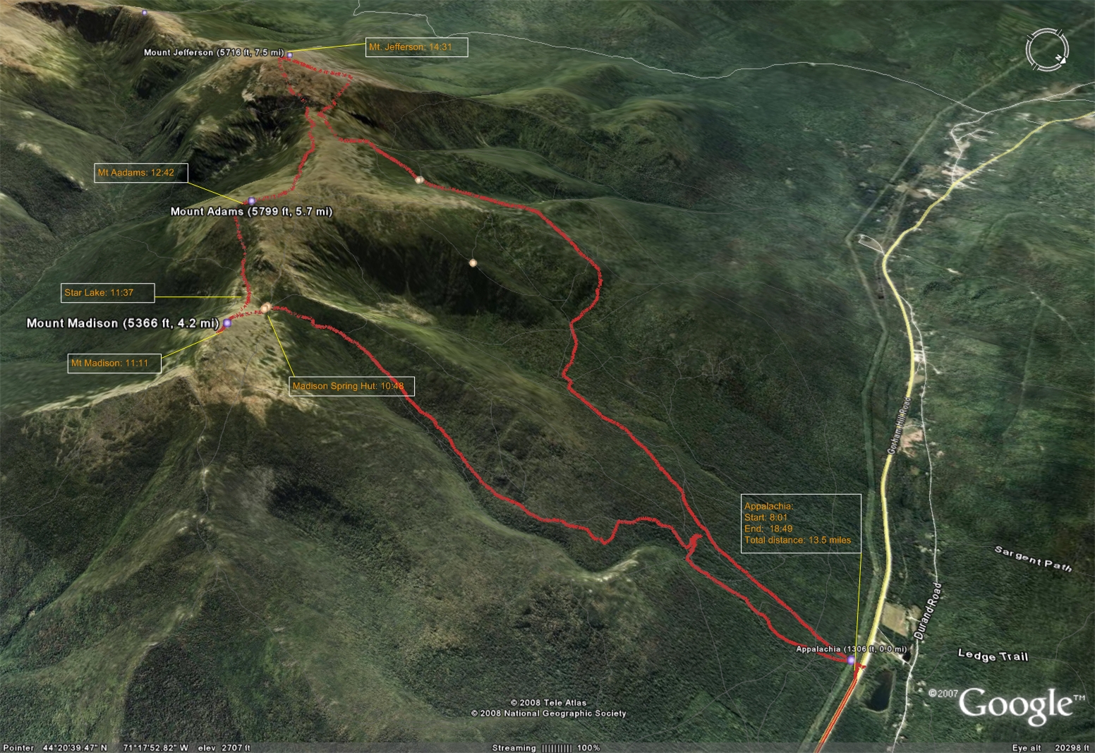
Prologue
After hiking Madison and Adams on March 17, 2008, I was determined to hike the three 5000 footers (Madison, Adams and Jefferson) with one trip. Originally I planned to do it on the weekend April 12 so I could participate some activities of the Boston Marathon on the following weekend including watching the women's marathon trials that rarely come to Boston. Unfortunately, a bug started from my GI then ascended to my throat for almost the entire week of April 6 to April 13. On the weekend of April 20, I still had light coughing but I did not want to delay this anymore because the following weekend my former graduate school advisor would visit me.
On Saturday April 19, I ran 7 miles in the morning and felt good. I left home at about 14:30 heading for Joe Dodge at Pinkham Notch. When I was approaching Joe Dodge, I saw more cars parked on the two sides of Rt. 16 and more people than I had ever seen in the area. Joe Dodge was packed with people. I was afraid that I would not be able to find a bed and have to resort to my plan B - lodging in the High Land Center which is an hour more drive. I did not book a bed because I had not had any problem in getting a room at Joe Dodge in the off season. When Ed, the AMC staffer at the front desk whom I had dealt with pleasantly before many time, told me only one vacancy for male was left, I was relieved. I leant that the annual Tuckerman Inferno Pentathlon (Run-Kayak-Bike- Hike-Ski) attracted thousands of people mainly speculators on that day.
I enjoyed the hearty AMC dinner with interesting people as usual. The author of multiple books on skiing and the presenter of the evening program, John Allen, and his wife sat across the table. He showed quite some interesting images including many historical ones at the evening program starting at 20:00.
I asked about the trail conditions for my Madison-Adams-Jefferson loop especially that of Randolph path that I planned to use for descending. I was told my ascending path, the Valley Way, was well packed and I might need traction but not snow shoes. The Randolph path would require snow shoes to avoid kneed deep postholes. The weather had been very mild for a long time and would continue to be so.
It was first time since 6 or 7 years ago that I had a roommate at Joe Dodge. He was from Cape Cod and came here for the very popular down hill skiing at the Tuckerman Ravine. I got up at 5:10 and tried to be very quiet and had my breakfast at 6:30 then headed out at about 7:20. I saw two moose drinking water by Rt. 16. I guess they like the ice melting salt from the road. I made a U-turn and took about a dozen pictures of them. I reached Appalachia at about 8:00.
The journey
The hike started at 8:01. I was wearing a pair of Sport Hill cotton running pants, a Performa Quick Dry long sleeve and a fleece jacket. It was so warm, I took off the jacket and wrapped around my waist soon after the start. In less than half a mile, I realized that most probably I did not lock my car. Since most of my valuables were at Joe Dodge, I decided to ignore it. The Valley Way was indeed very well packed but I still had postholing periodically. Streams were everywhere due to snow melting. I saw footprints going up and eventually I caught up with two gentlemen traveling in the same direction. Since I was taking a long loop, I did not try to hike along with them. I kept an even moderate pace. I ran across a group of six hikers who camped two nights before coming down and saw a bright yellow tent by the trail. I reached Madison Spring Hut at 10:48.
I met a group of 8 hikers resting in front of the hut which is closed. Some of them were wearing short-sleeves. I chatted with some of them very briefly. One of them told me the Start Trail path to Adams had a lot of snow but was manageable without snow shoes. I quickly hiked to the peak of Madison at 11:11.
Instead of following the trail marks, I marched down straight toward the Star Lake and reached it at 11:37. I could still feel the injury of my right ankle and it limited my descending pace because I needed to be gentle to the heel.
From the Star Lake, I followed foot prints toward Adams. Very soon, I was dealing with fairly deep snow and postholing frequently. The footprints did not follow the Star Lake Trail exactly and turned right up to deviate from the trail. I decided to use the trail all the way to Adams no matter how difficult it would be. The snow certainly did not make the ascent easy but it was manageable with bear boots. Approaching the summit, I ran into a steep section with deep snow and I struggled very hard to get through it. I reached the summit of Adams at 12:42 at a pace about 1.5 hours/mile, much slower than I originally expected.
I did not waste much time at the peak before descending toward Jefferson. I noticed that the west side had significantly less snow than the east side. After reaching the Gulfside Trail, I sat down to twisting my soaking wet socks to make them drier. I drank a bottle of water and ate a Powerbar. The Gulfside Trail was relatively easy until Edmands Col with only half of it covered with some snow. After Edmands Col, the snow got much deeper and the slope much steeper. The Jefferson Loop was quite challenging with snow. The good side of the trail condition is that it is not slippery and there is no danger of falling and sliding for long distance. I sipped and fell many times while ascending Adams and Jefferson, but I stopped right on the spots where I fell. I reached the summit of Jefferson at 14:41, more than an hour later than I originally expected.
I dislike going back on the same trail so I took the Castle Trail to the Cornice, then to the Randolph Path. The Castile Trail was on the west side of Jefferson and had very little snow. Soon after I turned onto the Cornice, I was dealing with deep snow on the north side of Jefferson. At one point, I was struggling to get me out of an almost hip deep posthole. The first mile on the Randolph path was not bad. Postholes were relatively shallow. After the first mile, I started to see very slippery surfaces that I had never seen so far during this hike. I tried to maneuver through them bearbooting until I reached a point of a very slippery and steep slope. I decided that I had no choice but putting on my crampons. After walking with crampons free of worrying about slipping, I regret that I did not put them earlier. The Randolph Path has the most diverse conditions - complete dry ground free of snow, slippery solid ice, deep snow and streams. I switched from the Randolph Path to the Short Line then the Air Line when close to Appalachia. I reached the Appalachia parking lot at 18:49. My car was indeed not locked but it had been untouched. Because I would not be able to get cellular signal at Joe Dodge, I used my mobile phone to try to send an email message to ABIOMED to inform my plan of taking the next day off as vacation so I could rest at Joe Dodge.
Epilogue
It was about 19:30 when I reached Joe Dodge and the dinner was over and dinning hall was empty. Katie, the very helpful and friendly AMC crew member, happened to work the evening shift and she kindly helped me get a plate of food. It was tasty. After a shower, I transferred the over a hundred pictures that I took from my camera to my laptop, then to a flash drive and I gave it to Katie to copy to the AMC's computer. Most pictures show the trail conditions so I thought they might be helpful for Katie and other AMC staffers to inform other hikers about the trail conditions.
I enjoyed another hearty breakfast and had a very nice conversation with Bill from Concord, NH who was there to join the big crowd to do the Tuckerman Ravine down hill skiing. When I was just about to leave, I realized that I forgot my Komperdell hiking poles at the Appalachia parking lot. They are super-light and super-strong poles with compass. Apparently my brain was not fully functional after the long hike the day before. I reported this to Katie to ask her to keep an eye on found items. She suggested to go to the Randolph Mountain Club's Web site and shoot them an email. I went back to the parking lot and saw no sign of the poles, then I took the route of Rt.3, Rt. 93 to come home. I posted a message to the Randolph Mountain Club's message board. later about the lost poles.
Weather statistics of the day for Mount Washington (the weather for other peaks of the range should be similar and slightly milder)
Monday, April 21, 2008
5:08 AM
24 Hour Statistics
Maximum Temperature: 46°F
Minimum Temperature: 36°F
Peak Wind Gust: SW 42 mph
Average Wind Speed: 21.3 mph
Liquid Precipitation: 0.00"
Snowfall: 0.0"
