Semi-Presidential Traverse
This is a report of a hike of the northern Presidential Range in New Hampshire, USA.
Date: 2008-05-17
Total distance: 15.06 miles (24.2 km)
Total Time: 11 hours 28 minutes
Start elevation: 1300 ft (397 m)
Total Ascent: 8689 ft (2650 m)
Total Descent: 7901 (2409 m)
Peaks: Mount Madison (5366 ft, 1637 m), Mount Adams (5799 ft, 1769 m), Mount
Jefferson (5716 ft, 1742 m), Mount Clay (5533 ft, 1687 m), Mount Washington
(6288 ft, 1918 m).
The following is a picture from Google Earth that does not reflect the weather
condition of the hike. More pictures are at Picasa.
Prologue
After I missed the bus to get on AMC’s Presidential Traverse trip in June 2007, I tried to organize a some colleagues to do it. It seemed that many were interested in it but needed more advanced notice. Therefore, in March 2008, I sent out a notice of Presidential Traverse in early June. Some people indicated their interest. I thought it might be a good idea to do a semi-Presidential Traverse from Appalachia to Pinkham Notch covering five Presidential - Madison, Adams, Jefferson, Clay and Washington totaling 13.9 miles and 7500 ft of accumulated elevation gain (both numbers turned out to be under-estimates). I received positive response from quite a few people. By the last day before the hike on May 17, only one person was committed to go. He is Hussein, a new colleague. Other people pulled out for various reasons.
I originally planned to take the afternoon of Friday, May 16 off to head to Joe Dodge at Pinkham Notch, but on Wednesday, I was notified there would be an opportunity to try a new product of which development I was involved in an in vivo study at the New England Medical Center on Friday. I had to prepare to arrive atJoe Dodge late night on Friday or drive from home to Appalachia on Saturday. The in vivo study has multiple parts. Mine was the last and unfortunately soon after it started, the pig‘s aorta was torn and we had to abort experiment. I had a Dim Sum lunch with five colleagues and gave some of them a ride back to our company in Danvers. It was already 4:20 when I started out from there. I had a 15 minutes soon after entering New Hampshire. I thought I would miss the nice dinner at Joe Dodge that starts at 18:00 but hoped to get some leftover. As soon as I parked my car at Joe Dodge, I ran to the front desk to book a bed and to my great pleasure I found that Friday’s dinner is always buffet from 18:00 to 20:00. I still had 40 minutes to enjoy that day’s Asian cuisine buffet - hot and sour chicken, stir fried mixed vegetables, rice with mixed vegetables, salad, egg drop soup. Rick from Maine was the only person sitting there. He enjoyed a day of skiing at the Tuckerman Ravine. He told me that it looked like the snow there could hold till early June. Skiing on natural snow in June! That was unexpected. Soon after we said that we were the last persons for the dinner, two large groups each of which had about 15 persons arrived. One group appeared to be girl scouts. It was very pleasant to see those healthy, fit kids having a blast.
I was writing this journal in the comfortable reading room after the dinner. To my pleasant surprise, Joe, my hiking friend, came into the room with his friend Bob and Nick. We chatted for a while and I brought out my map to discuss the hike that Bob was thinking. Bob never did any serious hiking before and is very fit. He wanted to hike from Pinkham Notch to Mizpath Hut that Joe would hike to after driving to the Highland Center. That would be a very strenuous hike. Joe was strongly against it. Initially I thought it might not be a bad idea to give it a shot because the risk would be very small. When Joe mentioned about hypoglycemia , I realized it might be a bad idea for an inexperienced hiker to have such strenuous first serious hike. If hypoglycemia happens in the wilderness with cold weather, things can go bad very quickly. I reversed my suggestion and suggested Bob to start from Mizpath together with Joe to explore how far he would be able to go safely from there.
I woke up at 4:50 and found it as drizzling and there would be chances of shower
during the day and light snow on Mount Washington early evening. I finally figured
out how to get cellular signals for my mobile phone at Pinkham Notch. I need
to be near Rt. 16 and try different directions, eventually I would be able to
get two bars of signal. I called Hussein at 5:50 and he was still on Rt. 95
about 2 hours away. As usual I had a very hearty breakfast for carbo-loading
and called him again at 7:30. He had not reached Conway yet. Finally he arrived
at about 8:30. We headed to Appalachia after he booked a bed in my room.
The Journey
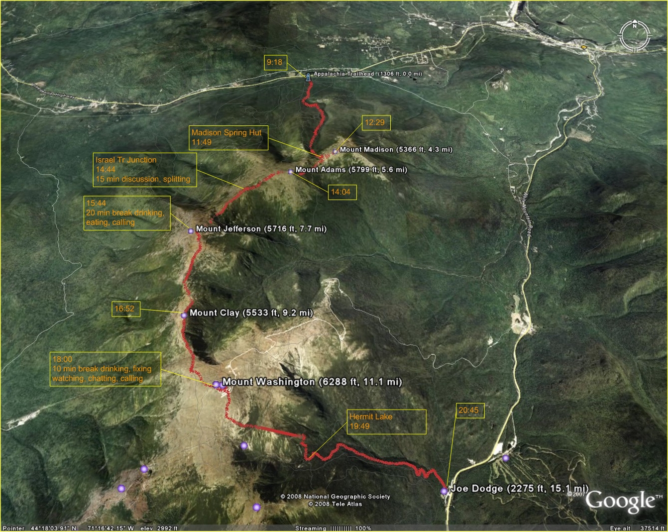
The hike finally started at 9:10. I was wearing a Drylete long sleeve, hiking
pants and Kamik hiking boots. The valley way was snow free until 3600 ft where
I saw the first spot of now. Then we say spotty snow and short stretches of
monorail until 4200 ft where continuous monorail started up till very close
to the Madison Spring Hut. The weather was warm and I sweated and the sweat
quickly evaporated. I felt thirsty soon, but I held from drinking water until
the Madison Hut. In retrospect, that was a mistake.
We started to feel wind as soon as we reached the Madison Spring Hut. I measured the wind speed my anemometer and the it was varying between 10 and 20 kmh. This is moderate for the Presidential Range. After a brief break, I resumed climbing and soon reached the summit of Madison at 12:29.
We marched down toward to the Star Lake in almost a straight line and reached it in about 20 minutes. We took the Star Lake Tr to Adams. I was surprised that the east side of Adams still had a few snowfields, but the snow was shallow so no postholing. We reached Adams at 14:04 and saw two groups of hikers totalling about 10 people. After a brief break, we followed the Israel Ridge Path and reached the Gulfside Trail in 0.5 miles. Hussein's pace has slowed down signficantly. At the point where the Israel Ridge Path diverges, I took a look at my GPS watch and noticed more than 5 hours had passed and we traveled only 6.2 miles. There were still three (two major and one minor) summits to conquer and about 8 miles (actually 9 miles I found later) to cover. With the pace we had been having, I thought, we would reach Joe Dodge at 22:00. I decided to have a discussion with Hussein and suggested three options: 1. Follow the original plan and hike all the peaks and reach Joe Dodge late night. Neither of us were prepared for night hiking. I brought only a tiny emergency flashlight. 2. He would skip the summits to save some time while I would cover them with faster pace. 3. He would return to Appalachia in 4 or 5 miles and I would finish the trip alone. He did not want to do night hiking and took the third option. After we split, I started jogging whenever possible to try to accelerate my pace. On Jeferson, I saw snowfields even larger than those on Adams, but no postholing. I reached Jefferson summit at 15:44.
I took a break of 20 minutes to call Hussein and found him doing all right, called Scott who left a message on my phone and was hiking Lafayette, then drank water and ate PowerBar. I found that I was running out of water. I brought only 3 16-oz bottles and 1 8-oz bottle of water.
After descending from Jefferson to the Gulfside Trail and passing the Sphinx Col, I took Mt. Clay Loop. I thought the summit of Clay is just a bump, so I was surprised by the over 500 feet climbing from the north to reach the peak. I passed the Clay summit at 16:52 and quickly got back to the Gulfside Trail. I followed cairns and soon I crossed the Cog Railway. I took a quick look at the map and it looked about right. I gradually ascended for about 0.5 miles and found I was descedning. I took a look at the map again and realized I took a wrong turn at the Cog Railway and followed the Westside Trail. The Mt. Washington summit was in my sight, so I took a straight line to go upt. I reached the Mount Washington summit at 16:00. I met a group of youngesters speaking French and helped each other taking pictures at the 6288 ft summit sign. I went to the Snack Bar to take a break. A gentleman there told me the snack bar was just closed. I learnt it was the first day for the snack bar to open in 2008. If I had known this, I would have tried my best to reach it while it was open. The watchband of my GPS watch came off and I had to fix it. I made another call to Hussein but could not reach him. Then I got a short message from him telling me he was already in my car. I called Scott and found he was heading home.
The sun was getting lower. I took the Tuckerman Ravine Trail to start my final descent. The section to the Headwall was closed as I was told the day before, so I took the Lion Head Trail at 0.4 miles from the summit. I was surprised by large snowfields on the trail. The sections in scrub areas were muddy. After passing the Lion Head, I caught a large group of students from Quebec. There were still monorails below the treeline. One short section was carved out of a snow wall. I was back to the Tuckerman Ravine Trail at 19:49. The fiirst half mile had packed snow offering highly desired cushioning but not slippery, then snow became intermittent for the next half of a mile. The last mile was completely dry. It was 20:45 when I finally reach Joe Dodge. I was very hungry. Hussein did me a favor by asking the kitchen to keep a plate of food for me. That was a very large plate of food coming with soup, dissert and salad. Everything was tasty. Mark, the most knowledgeable AMC employee at Joe Dodge was very friendly as always. He heated the food for me and I sneaked into the dinning hall where a presentaion was being given on hiking in California.
I had a very good night of sleep and woke up to a delicious and hearty break fast at Joe Dodge as usual.
Epilogue
I felt quite good, beter than I expected. I decided to do more hiking. I wanted to go back to the Dry River Trail where I got lost last year. I asked two AMC staffers and both of them told me there would be good chance the river was passable.
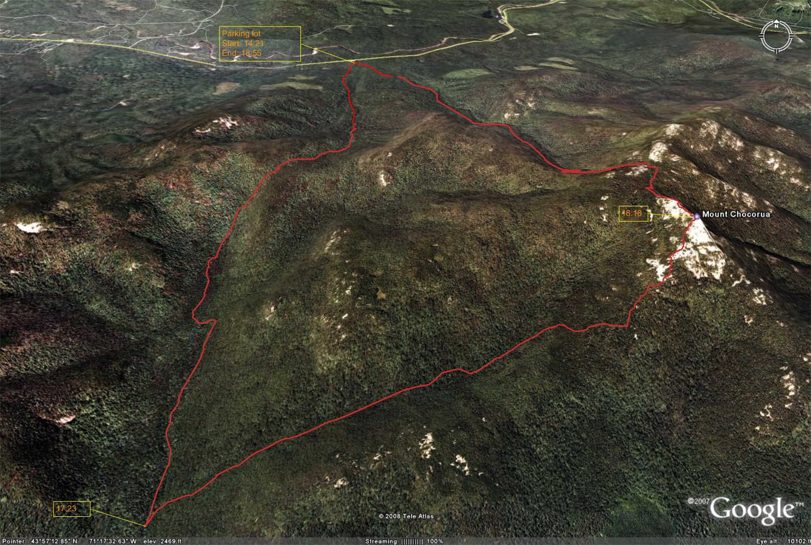
I could not find a Chinese restaurant for lunch on my way to the Dry River Trail, but I stopped by a general store and got some snacks and an annual US Forest Service pass for parking. The two ladies there were very friendly. I saw two trucks at the trailhead and I got on my way quickly. about one mile into the trail, I ran across an employee of the US Forest Service employee. He told me the bridge ahead was closed due to damage caused by high water and the river was not passable. I went ahead to the bridge which appeared to be OK but it was sealed at its two ends. I walked up a little bit and could not find any spot to cross without getting feet wet. I had some water and trail mix, then I decided to alter my plan - hiking Mout Chocorua.
I took the Bear Notch road first time to travel from Rt. 302 to Kancamangus (Rt. 112). It is a very beautiful road with quite a few view points. The parking lot at the trailhead of Champley Falls Trail requires pass and it was almost fall. I started my hike at 14:21. The trail is heavily traveled. I ran across a lot of poeple including kids of just a few years old coming down. To my surprise, there were still many stretches of monorail. My watchband fell again and the pin fell. It took me almost 10 minutes to find the tiny pin. After I passed the piper trail, I would not see anyone on the trails. It was 16:18 when I reached the summit of Chocorua that offers fantastic views of surrounding areas. It was getting windy and very cloudy. I did not want to take the original path to descent and considered a much longer path. I remember Scott hiked Mt. Chocorua in the past winter, I called him but did not reach him. I decided to take the risk by taking the Bee Line Trail and Bowlles Trail totalling 6 miles to descend. It started drizzling soon. I was almost jogging on the Bee Line trail that is almost flat after initial descent. I reached Bolles Trail at 17:23. The Bolles Trail had many long muddy stretches. At an old logging-camp site, there were two signs warning against traveling alone and advising only expert should travel the next section. It made me nervous a little bit, but eventually I figured they were obsolete winter signs. I did not read the map carefully and was surprised that I had to climb about 1000 feet before final descent. After the height-of-land, the trail crosses Twin Brook 10 times and the crossing spots could be a bit confusing. Fortunately the trail is very close to the trail and relatively well traveled, so one can always find it if looking around the brook.
I returned to the parking lot at 18:55 finding my car was the only one there.
On my way home, I stopped by at Song Bird Chinese restaurant to have a very good dinner. I arrived home past 22:00.